Home

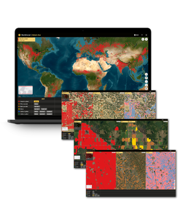
WorldCereal, an EO based system for global cropland monitoring


WorldCereal developed an efficient, agile and robust EO based system for timely global crop monitoring at field scale. 

The open-source WorldCereal system allows you to:

  • Create local to global annual cropland extent maps at 10 m resolution
  • Update the crop maps on a seasonal basis
  • Differentiate between actively irrigated and rainfed fields
  • Produce global maps of maize and wheat, two of the major staple crops

WorldCereal is a global R&D challenge aiming to engage the global agricultural community to achieve optimal results.

A FIRST SEASONALLY UPDATED GLOBAL ANNUAL CROPLAND MAP AT 10 M RESOLUTION

Objectives

WorldCereal focused on 4 specific objectives.

  • Demonstrate feasibility of global open-source and transparant crop mapping at field scale based on open EO datasets
  • Use existing cloud data providers, cloud computing capabilities and ICT infrastructure
  • Interact and collaborate with the global agricultural user community
  • Collaborate with local and global experts in the field to demonstrate WorldCereal 
     

WorldCereal aims to open and share agricultural reference data and support open science

Reference data

To generate accurate cropland and crop type maps, high quality reference data is indispensable for both training classification algorithms and validation of the final products. Therefore, WorldCereal engages with major domain players to stimulate and facilitate opening and sharing of reference data. By building an extensive network of partners and following a collaborative approach such agricultural data can be made available, accessible and reusable for the larger community.

Throughout the project, the consortium has collected and harmonized over 100 in situ data set from 2017-2021 for different regions in the world. These data can be explored in the reference data dashboard.


Of course contributions are still more than welcome. Are you able to share a dataset or part of a dataset, become one of the WorldCereal data providers. Expanding the database would be very welcome especially in area where data are lacking (Africa, Asia and Latin America). Continuation of collecting and harmonizing reference data will support the GEOGLAM community and create a stronger knowledge base for further and more impactful research and data science. As a WorldCereal data provider you will contribute to advance the state-of-the-art of global crop mapping and be at the forefront of this global innovative initiative. You can easily apply for a login to contribute data sets. These sets will be curated before publication.

A NEW AND INNOVATIVE SYSTEM BUILDING ON EXISTING INITIATIVES

WorldCereal counts on the global agricultural monitoring community to share high-quality in-situ data to train and validate the custom-developed crop classification algorithms.

To kickstart the WorldCereal project, the team organized an online agricultural survey to collect as many reference data as possible, and performed interviews with key user to refine the user requirements. Project Coordinator Sven Gilliams shares some first results!

We are currently making an inventory of agricultural reference datasets. In particular, we are looking for spatially explicit information on land cover (cropland extent), crop type and irrigation practices. If you are willing and able to share a dataset or a part of a dataset, we would kindly lik

A collaborative approach to make agricultural data available, accessible and reusable

Users

WordCereal is supported by the WorldCereal Champion users as well as a professional user network for in situ data collection, co-validation of the products and to showcase the usage.

WorldCereal recognizes the essential expertise of the agricultural user community to achieve well calibrated products at the global scale. For this reason, and to maximize and showcase the usability of the system and generated products, WorldCereal was co-designed with the users, through several use cases that are related to GEOGLAM and the SDGs. The selected key user organizations set the requirements for the WorldCereal products and system. They also validated and assessed the utility of the products and supported the consortium with access to reference data sets and their expertise on agricultural mapping and monitoring.