Accurate estimates on cropped area, crop type distributions and irrigation practices play an important role in guiding policy decisions related to food & water security [1]. In June 2020, the ESA WorldCereal consortium embarked on a scientific journey to demonstrate the feasibility of global crop mapping at field scale. As a result, in 2023 WorldCereal released the first global, seasonally updated maps of temporary crops, crop type (maize, winter cereals and spring cereals) and irrigation for the year 2021 at 10 m spatial resolution. More details on the approach and findings are available in our recently published paper [2].
ESA WorldCereal Phase II officially kicked off
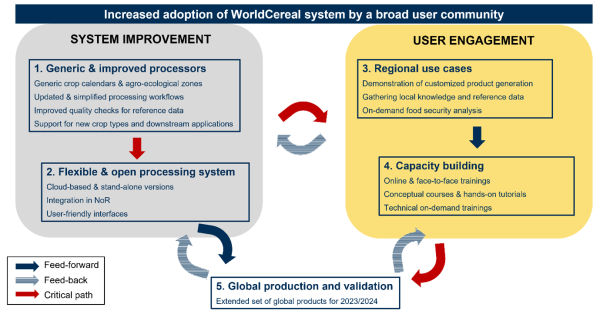
Since December 2023 ESA WorldCereal has entered a new 3-year phase in which the consortium primarily aims to boost user uptake of the system by the broad agricultural monitoring community. This will be accomplished through a combination of system improvement and dedicated user engagement activities.
Enhance accessibility and flexibility
The WorldCereal system will be integrated into OpenEO and implemented as a cloud-based processing service in the new Copernicus Data Space Ecosystem, and eventually also offered through the ESA Network of Resources (NoR), as such greatly enhancing accessibility of the classification system. On top of that, the WorldCereal crop calendars and classification workflows will be revised to offer more flexibility to the user, allowing the generation of fully customized crop type products.
Focus on user uptake
Aside from the upgrades to the system itself, the WorldCereal consortium will focus on demonstrating the new system’s capabilities through a series of regional use cases and by regularly informing the community on the use of the system through capacity building activities, including online webinars, face-to-face trainings and Massive Open Online Courses (MOOCs).
Extend the WorldCereal product suite
Finally, at the end of the new project phase, we will generate and validate a new series of global temporary crops and crop type products, extending the current product suite with 8 new crops (sunflower, rapeseed, millet, sorghum, wheat, barley, rye and soybean). To support these activities, the consortium will heavily invest in updating and extending the WorldCereal open and harmonized in-situ reference database, enabling a broad user community to easily access and contribute to this growing database of training/validation data for agricultural monitoring purposes at field scale.
ESA WorldCereal Phase II will be carried out by a consortium of six partners: VITO Remote Sensing (prima contractor, Belgium), International Institute for Applied Systems Analysis (Austria), University of Strasbourg, (France), University of Valencia, (Spain), Wageningen Applied Research (The Netherlands), and GISAT (Czech Republic).
[1] See, L., Gilliams, S., Conchedda, G., Degerickx, J., Van Tricht, K., Fritz, S., Lesiv, M., Laso Bayas, J.C., Rosero, J., Tubiello, F.N., and Szantoi, Z. (2023). Dynamic global-scale crop and irrigation monitoring. Nature Food DOI: 10.1038/s43016-023-00841-7
[2] Van Tricht, K., Degerickx, J., Gilliams, S., Zanaga, D., Battude, M., Grosu, A., Brombacher, J., Lesiv, M., Bayas, J. C. L., Karanam, S., Fritz, S., Becker-Reshef, I., Franch, B., Mollà-Bononad, B., Boogaard, H., Pratihast, A. K., and Szantoi, Z.: WorldCereal: a dynamic open-source system for global-scale, seasonal, and reproducible crop and irrigation mapping, Earth Syst. Sci. Data Discuss. [preprint], https://doi.org/10.5194/essd-2023-184, in review, 2023.
Stay informed
Stay tuned about WorldCereal Phase II via the WorldCereal social media accounts and subscribe to the WorldCereal mailing to receive important updates via email.
- NEW: LinkedIn esa-worldcereal
- X: @ESA_WorldCereal


