Comparing the WorldCereal global products 2021 with official FAOSTAT land use statistics
In a new report, FAO evaluated the accuracy and reliability of WorldCereal’s high-resolution cropland, crop type and irrigated area maps by comparing them with FAOSTAT datasets and aligning key variables for consistency.
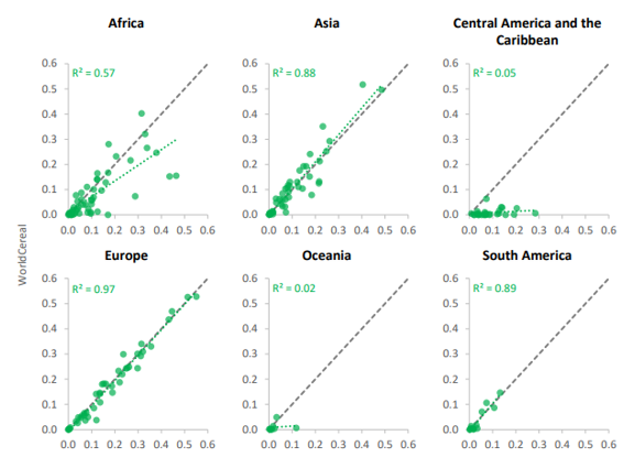
The results are striking: WorldCereal data demonstrated a high degree of correlation with FAOSTAT statistics, particularly for cereals and irrigated areas (R² around 0.9) and temporary crops (R² = 0.75). This strong agreement highlights the potential of satellite-derived products to support and refine global agricultural statistics.
The quote from FAO is a major milestone for WorldCereal, reinforcing the project’s goal of delivering robust, scalable, and operational solutions for global crop monitoring. It is a testament to the effectiveness of open, high-resolution, and seasonally updated land cover and crop type maps.

A strong foundation for the future
The collaboration between FAO and WorldCereal does not stop here. This study paves the way for further integration of Earth Observation data with statistical approaches, improving our ability to track agricultural production, food security, and climate change impacts. The detailed spatial analysis conducted in this FAO report (see example in Figure 1) constitutes valuable feedback towards the WorldCereal team. By refining methodologies and incorporating new reference data sources, especially in those regions highlighted by the FAO study, the next iterations of WorldCereal products will continue to improve in accuracy, and usability.
As we advance into the current phase of the project, the insights from this FAO analysis serve as a powerful endorsement of our approach. The WorldCereal community remains committed to enhancing the accessibility and usability of satellite-derived crop maps, ensuring that policymakers, researchers, and farmers alike can rely on the best possible information for decision-making.