Quick Start

The WorldCereal Reference Data Module (RDM) hosts all harmonised reference data. It also provides a convenient web interface and associated API service that allows you to easily discover, download, harmonise, contribute, manage, and publish reference data for crop mapping.

Find out more about the technical background of the RDM and its functionalities, including step-by-step instructions through our dedicated documentation portal.
Want to learn more about our data harmonisation procedures, how we ensure top-notch data quality, or about the impact of reference data quantity and quality on crop type maps? Attend our free online course on Reference Data for Crop Mapping!
Introduction to The WorldCereal reference data module
In order to effectively monitor food security at global scale and reach the Zero Hunger Sustainable Development Goal, having access to reliable information on the proportion of productive agricultural area is key. At present there is no timely, global view of the total agricultural area, nor of the proportion occupied by the major food crops around the world. WorldCereal is therefore developing an efficient, agile and robust processing system which can derive this information from satellite imagery. This service and the resulting global to local maps can additionally support other global crop monitoring services at field scale.
To generate accurate cropland and crop type maps, high quality in-situ reference data is indispensable for both training classification algorithms and validation of the final products. To this end, the WorldCereal Reference Data Module (RDM) has been set up. This module hosts datasets from various providers with standardized metadata and attributes mapped to a unified crop type legend. Built-in automated data quality checks and careful curation performed by WorldCereal data moderators ensure high and transparent data quality. Through the RDM, users can view, query, download, contribute and share in-situ reference data. An extensive set of automated tools takes care of data harmonization to the WorldCereal standards, thereby effectively taking away most of the burden from the user. More practical information on the use of the WorldCereal RDM can be found through our dedicated documentation portal.
Discover more about our mission and approach related to reference data, how to access our harmonized dataset and how to contribute in the sections below.
Our mission regarding in-situ data
Research communities, donor agencies, and governments have been stressing the importance of data sharing, harmonization, and collaborative re-use of data for crop monitoring over the past decade. However, data discovery, gathering, managing and harmonizing from different sources is a challenging task. Further, ethical, legal, and consent-related restrictions associated with sharing represent a common dilemma faced by international research projects. The WorldCereal team aims to improve this situation and is therefore:
- Discovering in-situ data across the world
- Developing and applying data curation and harmonization
- Providing standardized access to a metadata catalogue and the in-situ data itself
- Building trust and long-term relationships with the global crop mapping community
- Building the first global harmonized in-situ dataset for agricultural monitoring
Gathering and harmonizing in-situ data
The WorldCereal consortium is continuously gathering and harmonizing new in-situ reference datasets from various partners across the globe. In order to be useful to us, the data should at minimum hold the following information: a detailed location of the field, the land cover and/or crop type present and the observation date and/or growing season. Data should preferably be more recent than 2017. We are currently targeting in-situ data sets, but recent, validated and high-quality local crop type maps can also be of value.
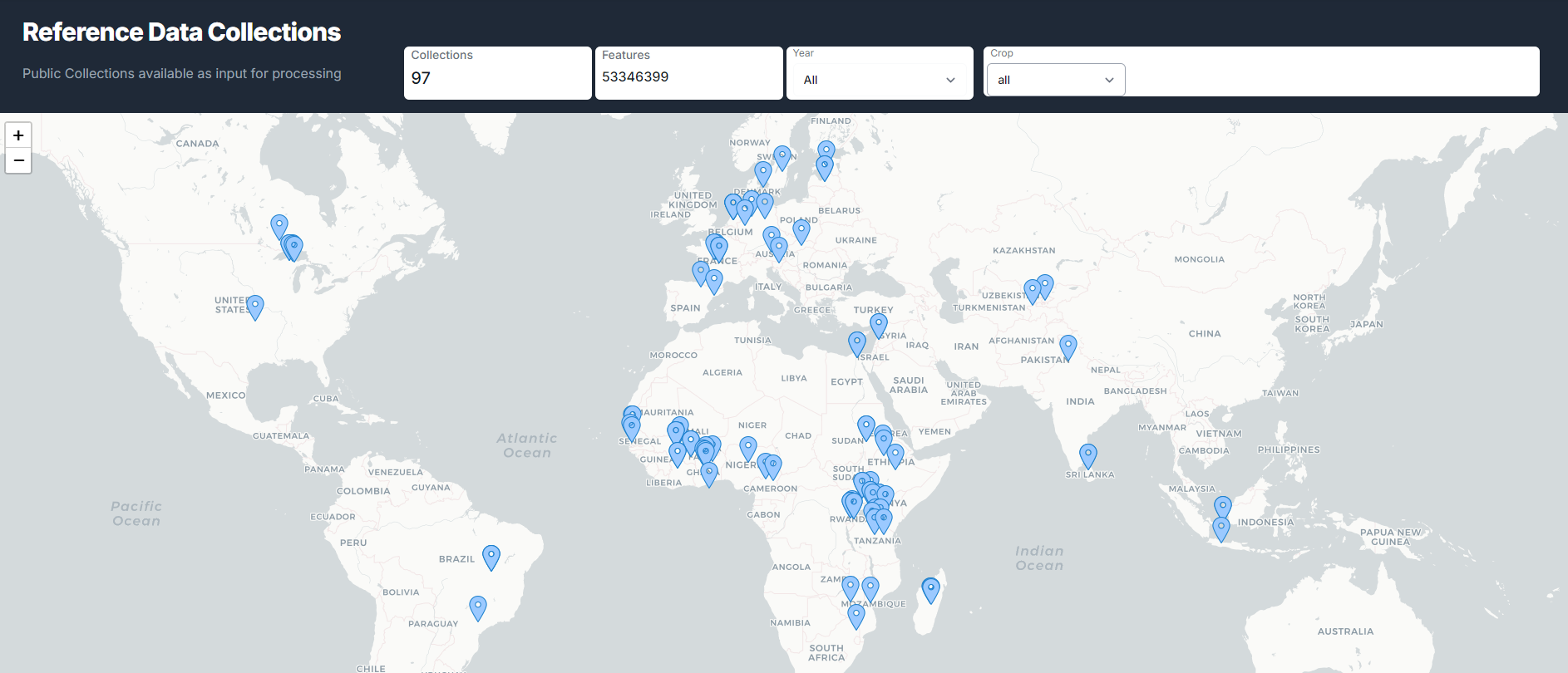
We already collected data from various regions in Europe, North and South America and Africa coming from various sources but unfortunately large regions are not yet covered, specifically in Asia. See the figure below for an overview of publicly available datasets in our growing global database.
Each dataset ingested in our global database has been harmonized to a common and hierarchical land cover and crop type legend. Moreover, we annotated the datasets giving credit to the owner. We compiled a harmonized metadata sheet, briefly describing the dataset in terms of name, DOI, license, citation, data type, objective and observation method. Finally, we ran a dedicated quality control workflow which removes obvious errors and rates the dataset quality in terms of temporal, spatial and thematic accuracy.
More information regarding the availability of in-situ reference data at the end of WorldCereal Phase I and the procedures for data harmonization and standardization can be found in this publication.
Benefits for sharing data
Although our algorithms have shown a great deal of robustness towards reference data gaps, we are constantly on the look-out for more data covering all climate zones and cropping systems to improve the quality of our maps. Important to realize here is that any improvement to our algorithms will not only result in improved global products, but will also affect the quality of any local/customized crop type map generated by any user of the WorldCereal processing system.
We believe there is more useful data out there. For this the WorldCereal team is counting on the global agricultural monitoring community.
Would you like to contribute and profit from improved algorithms and higher quality cropland and crop type maps for your region of interest? Get started with the Reference Data Module today or contact us to discuss future collaboration.
Directly supporting WorldCereal by contributing data has multiple benefits:
- Effectively contributing to higher quality global cropland/crop type maps for your specific area of interest
- Ensuring your own custom crop type model and resulting products show optimal performance for your area of interest
- Possibility of obtaining free processing credits for use of the WorldCereal system
- Possibility for joint publications
- Increased visibility and attribution through official WorldCereal publications, promotion, capacity building and outreach activities
Note on data privacy
Upon contributing in-situ reference data to the WorldCereal Reference Data Module, you will be able to choose between three distinct data privacy levels:
- Private access: only you will be able to view and use the data to train your custom crop type detection algorithms using our processing system.
- Restricted access: data can only be viewed and used by the data contributor itself and the WorldCereal consortium. Your data will be used only in the context of the WorldCereal project to enhance our global crop type identification algorithms.
- Public access: data can be viewed and used by any user of the WorldCereal system and as such will benefit the agricultural monitoring community.
Supporting the general move towards open and FAIR data, we highly encourage potential contributors to opt for either the restricted or public access.