A crop type mapping system to support any crop type
During Phase I of the WorldCereal project, the consortium produced the first season-specific, global crop type maps for maize, winter cereals and spring cereals for 2021. To achieve this, the development of global crop calendars for maize and wheat, indicating start and end of the major growing seasons for these crops, has been essential. In a nutshell, the approach followed included the creation of a unified dataset of planting and harvesting dates from already available calendars, provided by reputable institutions such as GEOGLAM Crop Monitor, USDA-FAS, FAO and ASAP. Based on the available data, a global grid of points was defined, ensuring a high concentration of either maize or wheat crops in the immediate vicinity of each point. A spatially aware Random Forest machine learning model was then trained that estimates planting and harvesting dates, mainly based on ECMWF Re-Analysis climate data (ERA5). This resulted in the definition of three seasons: a winter cereals season (indicating the main growing season for wheat, barley and rye), a primary maize season and an optional secondary maize season (the latter mostly restricted to tropical areas). More information about Phase I crop calendars can be found in this publication.
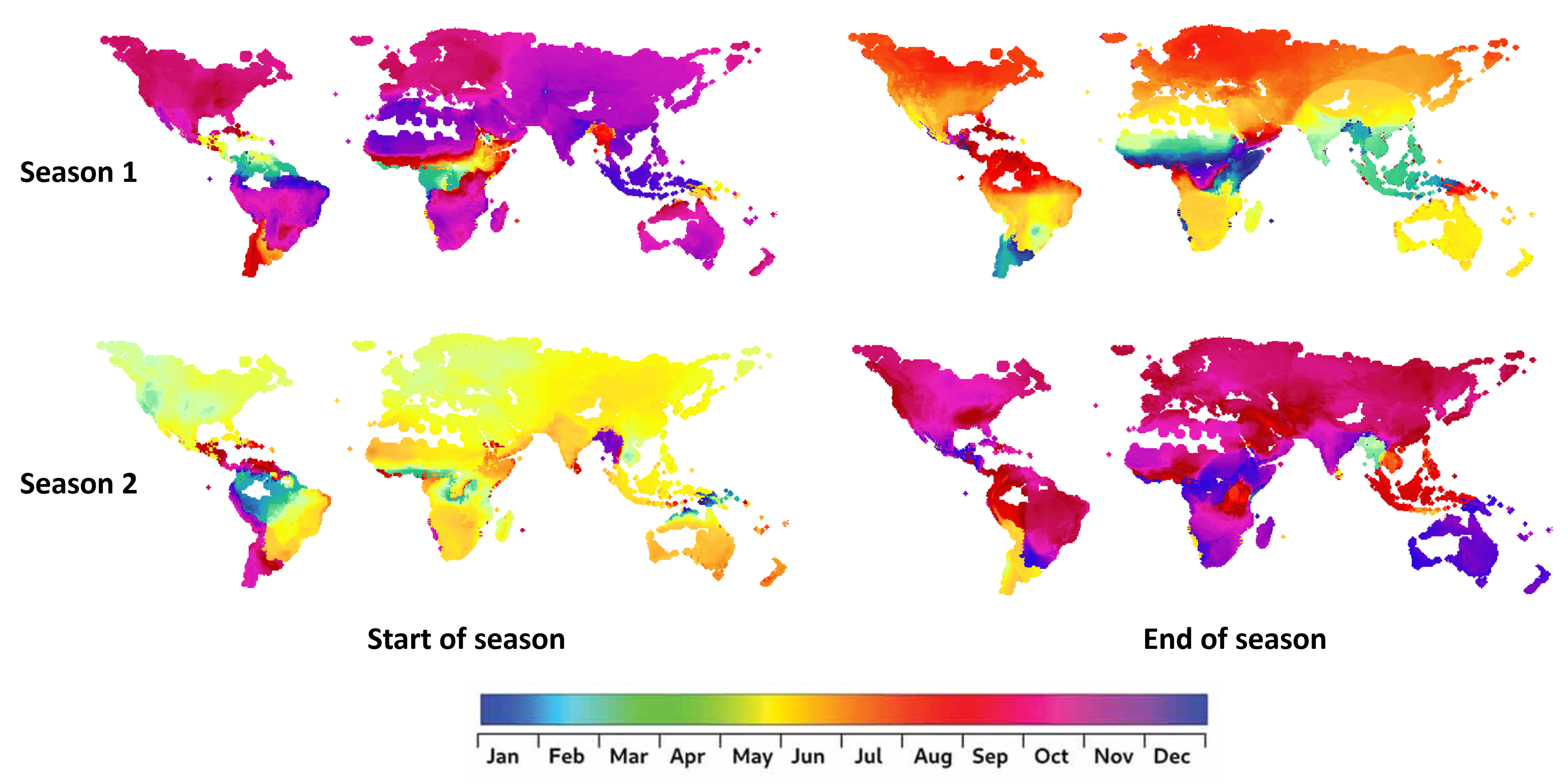
Now, the WorldCereal project is continuing its journey towards a global and season-specific crop type mapping system, which will no longer be restricted to maize and cereals but instead should be able to support any crop type defined by the user. The next global products will additionally cover sunflower, rapeseed, millet, sorghum, wheat, barley, rye and soybean. For this reason, we are moving from crop type specific calendars to generic calendars capturing the two most dominant growing seasons of temporary crops anywhere on the globe (Figure 1) as the default calendars to be used in the WorldCereal processing system.
WorldCereal crop calendars
Significant improvements to boost crop calendar accuracy
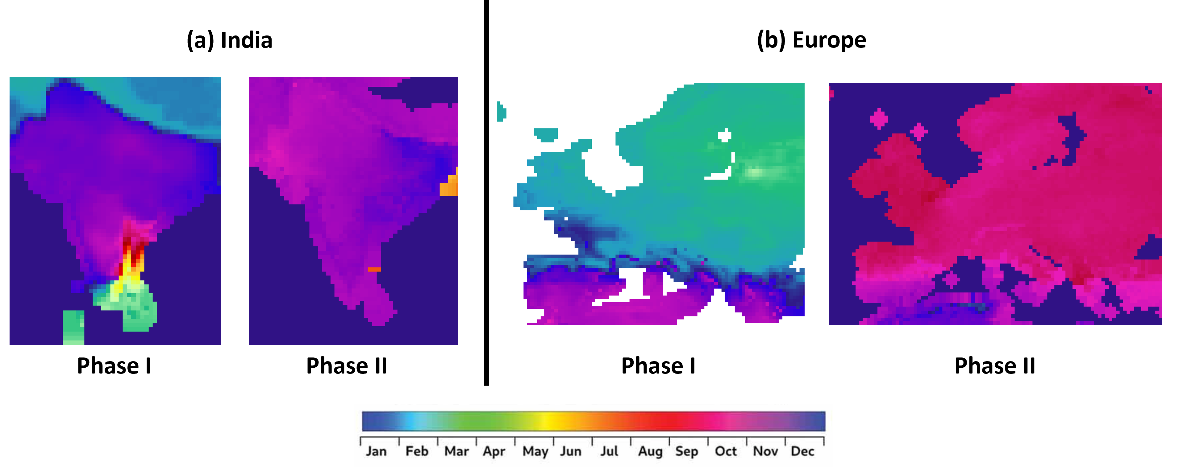
To generate this preliminary version of the new global crop calendars, the existing crop calendars for wheat and maize were first improved by extending the set of training points, focusing on areas showing high residuals in the previous version of the model, and enhancing the spatial representativeness. Harmonized Landsat-Sentinel-2 (HLS) NDVI time series extracted through Google Earth Engine enabled the retrieval of accurate planting and harvesting dates (based on the LSP method) for new training points. As such, the number of winter wheat points increased from 356 to 746, while maize (main season) points increased from 443 to 575. Based on an independent validation, these changes showed a significant boost in crop calendar accuracy (RMSE reduced by 22% and 24% for wheat and maize respectively) and also visually reduced spatial artefacts in the resulting calendars (Figure 2a). Specifically, regarding winter wheat, the pre-dormancy period that this crop experiences in many boreal regions, which was excluded from the Phase I calendars, was now explicitly introduced to better reflect the actual planting date, which is more relevant to the end users (Figure 2b).
Two most dominant temporary crop seasons
To convert the three seasons from Phase I into the two most dominant temporary crop seasons, the secondary maize season from Phase I, mainly located in tropical areas, has been merged with either the winter wheat or the primary maize season, depending on the specific region, always ensuring spatial consistency. Next, the crop type dependency of the calendars was removed by renaming the two seasons on a per-pixel basis to season 1 and season 2, where season 1 represents the season with the earliest end of season within the calendar year. Additional checks were done based on existing USDA-FAS calendars confirming the resulting two seasons should cover most other temporary crops aside from wheat and maize.
To assess and improve the quality of the current crop calendar products across different regions, we consider that it is critical to receive feedback from local experts. Therefore, we call upon you, the community, to review this preliminary version. In case you would like to assist, please get in touch through our contact form to get early access to the calendars and provide your valuable insights to our team.
Spatially detailed information on the crop calendars allows crop type mapping and crop yield algorithms to account for specific local circumstances while also maximizing their robustness and global applicability.