Introduction
High quality in-situ reference data on land cover and crop types is indispensable for generating and validating regional to global crop maps based on satellite observations. This reference data is collected by different organizations, using different collection protocols and data formats, and subject to different redistribution licenses. As a result, reference data is typically not FAIR (findable – accessible – interoperable – reusable), limiting its added value to the crop monitoring community.
Recognizing the crucial role of reference data, WorldCereal has embarked on a mission to collect, harmonize and redistribute such data through its Reference Data Module (RDM). This module hosts datasets from various providers with standardized metadata and attributes, mapped to a unified crop type legend. Built-in automated data quality checks and careful curation performed by WorldCereal moderators ensure high and transparent data quality. Through the RDM, users can view, query, download, contribute and share in-situ reference data. Its seamless integration into our processing system allows to immediately use the data for training your custom crop identification model. An extensive set of automated tools takes care of harmonizing your dataset to the WorldCereal standards, making it easier than ever to freely combine data from multiple sources. By freely offering these convenient tools, we hope to accelerate the trend of data openness and sharing within the crop monitoring community. Obviously, we count on (data) contributions from each and everyone of you (yes, you!) to make this happen.
Objectives
In this first WorldCereal online course, we will take a deep-dive into the topic of reference data for crop mapping, zooming in on different aspects including collection, harmonization, quality assurance and the impact of data quality/quantity on crop type map accuracy. As such, this course provides an in-depth understanding of reference data requirements (in terms of quantity, quality and format) and processing in the context of land cover and crop type mapping. All of this will be accompanied with step-by-step guides on how to use the WorldCereal RDM to find, download, contribute and share reference data.
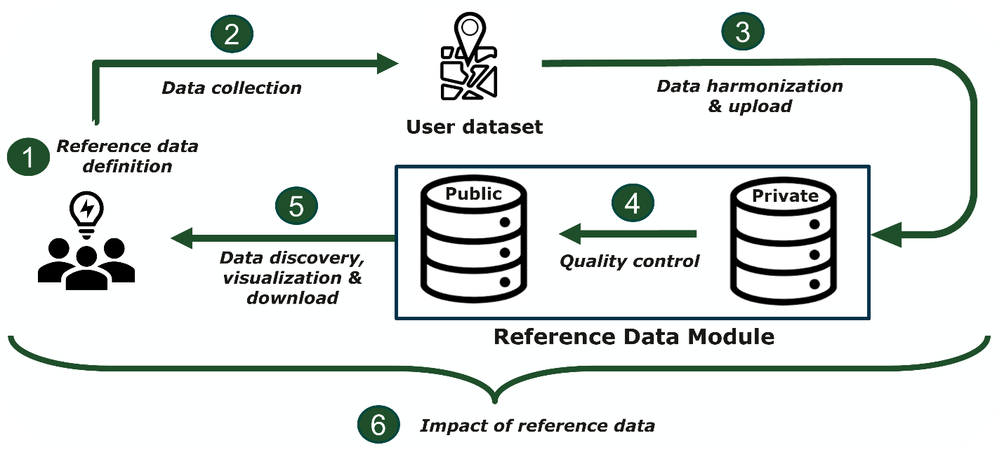
The figure below illustrates how reference data typically travels through the WorldCereal system and highlights the different components of this course.
In summary, this course’s key objectives include:
- Highlight and demonstrate the importance of reference data for satellite data analysis in crop monitoring.
- Provide an overview of available tools and best practices for reference data collection.
- Explain the benefits of and methods for harmonizing heterogenous reference datasets.
- Offer insights into quality assurance for reference data.
- Explain and showcase the different functionalities of the WorldCereal Reference Data Module (RDM), including data upload and data exploration.
Need help or support?
The materials offered in this free online course are meant to be self-explanatory.
Yet, you might at some point feel the need to discuss some of the topics further with the course instructors and/or participants. We got you covered!
We have created a dedicated discussion topic on our User Forum, so if you:
- Want to provide some feedback?
- Have any remaining questions?
- Want to discuss further upon a certain topic?
Feel free to reach out to us through the MOOC discussion topic, or create your own topic within the Reference data Section of our forum and actively engage in the growing WorldCereal community!