Within WorldCereal we have 4 specific objectives. We want to:
- demonstrate feasibility of global open-source and transparent crop mapping at field scale based on open EO datasets
- use existing cloud data providers, cloud computing capabilities and ICT infrastructure
- interact and collaborate with the global agricultural user community
- Collaborate with local and global experts in the field to demonstrate WorldCereal
Objective 1: Global crop mapping at field scale
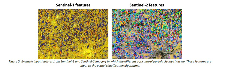
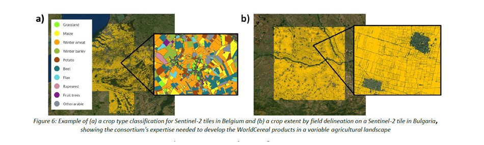
Our first specific objective is to demonstrate the feasibility of global crop mapping at field scale based on open EO datasets. The developed EO solutions will be open-source, containing transparant algorithms, and fully exploit high spatial and/or temporal resolution EO data such as Sentinel-1, Sentinel-2, Sentinel-3 and Landsat 8.
Within WorldCereal we want to exploit the complementarity between optical and radar time series. While optical imagery is especially sensitive to biophysical parameters, radar data reflects structural differences and are highly correlated with crop phenology. Radar data like Sentinel-1 is also weather-independent, which especially benefits cloudy regions with limited optical data, and it also adds complementary information to the optical signals, strongly increasing the ability to map the agricultural landscape. Landsat 8 data will be used as a supplementary optical information source whenever the amount of radar Sentinel-1 and optical Sentinel-2 is limited, and to provide thermal information which is important for the irrigation/non-irrigation classification algorithms.
Objective 2: Tools
Downloading massive amounts of data to obtain valuable and objective end user products is outdated and is therefore no longer a feasible approach. With the recent boosts in cloud computing and storage capacities, we have definitely entered a new era with respect to our ability of processing massive amounts of data in a highly efficient way.
As such, WorldCereal’s second specific objective is to ensure that the developed open source EO algorithms make full use of the existing cloud data providers, cloud computing capabilities and ICT infrastructure. The EO system and algorithms need to be fully agnostic to cloud or ICT infrastructure and portable from one system to another.
To ensure the best possible quality of the WorldCereal products at global scale, existing reference datasets will be collected within the agricultural community. As part of the WorldCereal tools, users will therefore be able and encouraged to share reference datasets, thereby directly contributing to the product quality.
Objective 3: Collaboration
To make sure the EO based system meets the needs of our end users, interaction and collaboration are key. This is our third objective, i.e. interact with the wider agricultural user community and make sure we capture their needs and experience.
Throughout the project, users will be able to assess the performance of the system, check the accuracy of the products and evaluate the usefulness of the products for their organization.
Objective 4: Demonstrating the WorldCereal products
To achieve this objective, the WorldCereal consortium is supported by the WorldCereal Champion users. These Champion users will play a crucial role in demonstrating the WorldCereal products in case studies for GEOGLAM and SDG reporting.
- GEOGLAM, the Group on Earth Observations (GEO) Flagship Initiative on Global Agricultural Monitoring,
- the G20 Agricultural Market Information System (AMIS) (Policy/Economics/Trade)
- the FAO with its Global Early Warning and Information System of Food and Agriculture (GIEWS) department and the Land and Water department (Humanitarian/Early Warning/Water use efficiency
Additionally WordCereal can also count on its huge user network for in situ data collection, co-validation of the products and to showcase the usage of the WorldCereal products; AAFC, AFSIS, BAGE, CIMMYT, CIMMYT-GLTEN, DSSI, EU-JRC, GODAN, ICARDA, ICRISAT, IFPRI, INTA, JECAM, N2AFRICA, NASA Harvest, ONESOIL, Plant Village, RADI, ROTHAMSTED RESEARCH, WFP etc.
Lastly, GEOSYS - an Urthecast company – will offer its support to the WorldCereal project as a key end user covering the agricultural business aspects.